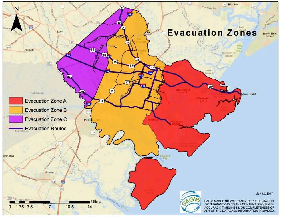
Evacuation Zones for Chatham County
After Hurricane Matthew, there was a need for greater understanding and preparation to ensure the safe and effective evacuation of Chatham County during a hurricane or tropical storm.
To better prepare for hurricane season, we are encouraging residents to learn the terminology that County officials will be using during an evacuation. Knowing the difference between an evacuation and mandatory evacuation orders will significantly affect how communities and residents will react and prepare for the threat of a hurricane.
CEMA has made finding which zone you live in possible with this interactive map. This will allow you to type in any address in Chatham County and easily identify which zone you are in.
An Evacuation Order will be issued when local officials feel it may be in your best interest to evacuate the targeted area. An Evacuation Order is a general statement used to encourage residents to evacuate.
A Mandatory Evacuation Order is an executive directive requiring all residents, visitors, businesses and others in the target area to evacuate. Personal discretion is not an option.
In addition, Chatham County has constructed new evacuation zones to ensure an efficient exit for all communities that are in the target area.
These zones are:
These zones are clear boundaries that are already established in Chatham County. Residents are familiar with these landmarks and should be able to easily identify which zone they live and work in.
Learn More
To learn more about evacuation zones in Chatham County, please click the link below.

Flood Zones Savannah
Definitions
X Flood Zone areas are considered to be Low Flood Risk areas. These areas are not regulated for floodplain management purposes by Chatham County and FEMA for home construction. Flood insurance is not required by FEMA but is recommended. Preferred Risk flood insurance policies are offered in this area.
Shaded X flood zone areas are considered to be Moderate Flood Risk areas. These areas are also not regulated for floodplain management purposes by Chatham County and FEMA for home construction. Within these areas there is a 0.2% annual chance of being flooded. These areas are commonly referred to as the 500-year flood zones or X-500 areas. Flood insurance is not required by FEMA but is recommended. Preferred Risk flood insurance policies are NOT offered in this area.
AE and VE flood zones are considered by FEMA as High-Risk flood areas. These areas are commonly referred to as the 100-year floodplain or areas located in the Special Flood Hazard Area (SFHA). In general, what this means to the average homeowner building in AE areas, if the home has a crawl space it must also have hydrostatic vents installed in the walls of the crawl space. All utilities such as, AC units and electrical outlets, must be elevated to the Base Flood Elevation (BFE) plus 1-foot. Chatham County has a 1-foot Free Board requirement so all new construction must be at the BFE plus 1 foot or so called the Design Base Flood Elevation (DBFE). If there is a federally backed loan associated with the home purchase, flood insurance is required by FEMA. Within VE flood zones, the homes must be constructed much like the homes located near the beach on Tybee Island, built up on piles, posts or piers with deep foundation embedment to protect them from wave action and scour. For these homes, the BFE height requirement is measured from the lowest horizontal structural member. Other stipulations apply within both of these flood zones.
And to help you understand the 100-year chance concept, picture this: There is a box in front of you containing 99 clear marbles and 1 red marble. All the marbles represent one year so there are 100 years in the box. Your exercise will be to close your eyes, reach in the box and select a marble. Chances are you will pull a clear marble from the box. No flooding occurred that year. So you then place that marble back in the box, shuffle them around and select again. If you pull the red marble, you have just been flooded. You then put the red marble back in the box and reshuffle. If you are unlucky like the people residing along the Mississippi and Missouri Rivers, you will select the red marble yet again, and again and again. For the 500-year flood zone, just add 400 more clear marbles and keep playing.
CoBRA stands for Coastal Barrier Resources Act. These are areas located along the coast which have been identified by the Federal Government to be protected from development. Structures built in these areas cannot get flood insurance coverage. Contact your local Floodplain Administrator (912) 652-7814 for more information.